MacArthur Park (Leyte Landing Memorial) on Red Beach, Palo, Leyte
20 October 2009
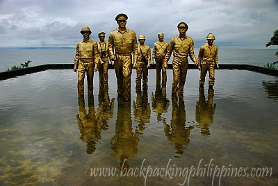
The most famous landmark and tourist attraction of Tacloban, though not really a part of the now highly-urbanized city, is MacArthur Park, now known as Leyte Landing Memorial. It dramatizes the landing of Gen. Douglas MacArthur on Read Beach with larger-than-life bronze statues of the general long with his entourage.
It was on October 20, 1944 when Gen. Douglas MacArthur waded ashore accompanied by then Philippine President Sergio Osmeña, Brig. Gen. Carlos P. Romulo (who'd become president of United Nations General Assembly) and Pres. Osmena's Aide-de-Camp Tony Madrigal (Don Antonio, the father of Senator Jamby Madrigal), to begin the liberation of Leyte Island and of the whole archipelago from the clutches of Imperial Japan.
 MacArthur Landing Park on Red Beach, Palo, Leyte
The beachhead in Palo town, a few minutes from Tacloban City, is not really colored red per se nor called as such due to red color of the blood-drenched sand, but a designation of the beach in planning by the US military. There's also Blue Beach in nearby Dulag town and similar conventions of beaches in La Union and Pangasinan in Lingayen Gulf during the landing in Luzon island and Yellow Beach in Zamboanga City.
 the MacArthur "shrine" with historical markers in view
the markers on the "shrine" reads:
"On this spot, Palo, Leyte, General Douglas MacArthur returned to the
Philippines on 20 October 1944 and personally led the swift drive
against the Japanese forces in the Philippines. President Sergio
Osmena arrived with General MacArthur and proceeded to reorganize, restore and administer the government of the commonwealth of the Philippines. Declared and National Historical Landmark 2004."
Alternate reports from actual observers and historians narrated how the dogmatic general spent five hours and three takes before the (in)famous video clip was recorded with him wading on Red Beach of Palo, Leyte, while the boats and his men on the shore were exposed to the blistering attacks of Kamikaze pilots from Pampanga that gravely put his men in danger because of his landing rehearsals typical of politicians for self-aggrandizement.
 MacArthur Park (Leyte Landing Memorial) with a person in view to add scale to the larger-than-life bronze statues inside a man-made lagoon on Red Beach
Three days after the historic Leyte landing, began the Battle of Leyte Gulf, the largest naval battle of World War II and one of the largest naval battles in history, that ended with the crushing defeat of the Imperial Japanese Navy at the hands of the Americans aided by the Royal Australian Navy.
Lastly, does anybody know why MacArthur chose to land on the beaches of Leyte and not anywhere else? Historians know MacArthur initially planned to invade Mindanao particularly Sarangani Bay on December 20, 1944 but was diverted to Leyte two months ahead of schedule. It has something to do with guerillas (the unsung heroes) from Cebu. More on this on a future post.
How to get to MacArthur Park (Leyte Landing Memorial):
Commuting to MacArthur Shrine takes just two rides from Tacloban airport. First, ride a Tacloban bound jeep outside the Tacloban Aiport arrival area. Alight on the area known to the locals as Coca Cola (a park with a Coke factory with prominent Coke, Sprite and Royal giant cans as landmarks), cross the street then transfer to a jeepney bound for Baras (not Marasbaras) that passes by the park.
Those who took RORO buses or ferries to Tacloban can go there by taking a jeepney to Tacloban City center and transfer to Baras-bound jeeps near Tacloban Market, even Robinsons Tacloban mall.
It was on October 20, 1944 when Gen. Douglas MacArthur waded ashore accompanied by then Philippine President Sergio Osmeña, Brig. Gen. Carlos P. Romulo (who'd become president of United Nations General Assembly) and Pres. Osmena's Aide-de-Camp Tony Madrigal (Don Antonio, the father of Senator Jamby Madrigal), to begin the liberation of Leyte Island and of the whole archipelago from the clutches of Imperial Japan.
 MacArthur Landing Park on Red Beach, Palo, Leyte
The beachhead in Palo town, a few minutes from Tacloban City, is not really colored red per se nor called as such due to red color of the blood-drenched sand, but a designation of the beach in planning by the US military. There's also Blue Beach in nearby Dulag town and similar conventions of beaches in La Union and Pangasinan in Lingayen Gulf during the landing in Luzon island and Yellow Beach in Zamboanga City.
 the MacArthur "shrine" with historical markers in view
the markers on the "shrine" reads:
"On this spot, Palo, Leyte, General Douglas MacArthur returned to the
Philippines on 20 October 1944 and personally led the swift drive
against the Japanese forces in the Philippines. President Sergio
Osmena arrived with General MacArthur and proceeded to reorganize, restore and administer the government of the commonwealth of the Philippines. Declared and National Historical Landmark 2004."
Alternate reports from actual observers and historians narrated how the dogmatic general spent five hours and three takes before the (in)famous video clip was recorded with him wading on Red Beach of Palo, Leyte, while the boats and his men on the shore were exposed to the blistering attacks of Kamikaze pilots from Pampanga that gravely put his men in danger because of his landing rehearsals typical of politicians for self-aggrandizement.
 MacArthur Park (Leyte Landing Memorial) with a person in view to add scale to the larger-than-life bronze statues inside a man-made lagoon on Red Beach
Three days after the historic Leyte landing, began the Battle of Leyte Gulf, the largest naval battle of World War II and one of the largest naval battles in history, that ended with the crushing defeat of the Imperial Japanese Navy at the hands of the Americans aided by the Royal Australian Navy.
Lastly, does anybody know why MacArthur chose to land on the beaches of Leyte and not anywhere else? Historians know MacArthur initially planned to invade Mindanao particularly Sarangani Bay on December 20, 1944 but was diverted to Leyte two months ahead of schedule. It has something to do with guerillas (the unsung heroes) from Cebu. More on this on a future post.
How to get to MacArthur Park (Leyte Landing Memorial):
Commuting to MacArthur Shrine takes just two rides from Tacloban airport. First, ride a Tacloban bound jeep outside the Tacloban Aiport arrival area. Alight on the area known to the locals as Coca Cola (a park with a Coke factory with prominent Coke, Sprite and Royal giant cans as landmarks), cross the street then transfer to a jeepney bound for Baras (not Marasbaras) that passes by the park.
Those who took RORO buses or ferries to Tacloban can go there by taking a jeepney to Tacloban City center and transfer to Baras-bound jeeps near Tacloban Market, even Robinsons Tacloban mall.
Labels: Eastern Visayas, Landmarks, Leyte, World War II
posted by GingGoy @ 9:52 PM,
,


Mabuhay! Welcome Rotonda in Manila and Quezon City
01 January 2009
A fitting landmark to welcome the New Year, a photo of Welcome Rotonda, now called Mabuhay Rotonda, located at the boundary of the City of Manila and Quezon City, also marks the end-points of four major streets: España Boulevard, Quezon Avenue, E. Rodriguez Avenue and Mayon St.
 picture of the rotonda (roundabout) taken from Quezon City side (Canon Ixus 30). The monuments back is Espana Boulevard leading to Quiapo
History of Welcome Rotonda (now Mabuhay Rotonda)
Architect Luciano V. Aquino designed and built the structure from piles of marble in 1948 during the term of Mayor Ponciano Bernardo when Quezon City was declared the new capital of the Philippines. It was renamed Mabuhay Rotonda in 1995 to reflect a more Filipino name (Mabuhay means Long Live in Filipino), during the term of Mayor Ismael Mathay.
The roundabout is a declared freedom park where demonstrations and rallies can be held. When Tutubi passed by, activists displayed banners calling for the resumption of the GRP-MILF peace talks. Who wouldn't want peace?
---
How to get there:
Commuting to Welcome Rotonda is easy, jeepneys from Manila going to Quezon City with signbords Cubao, Project 2-3, Project 4, Project 6, Project 7, Project 8, and Lagro/Fairview pass by the imposing landmark. From MRT stations of Quezon Avenue, North Avenue, GMA-Kamuning and Cubao, jeepneys going to Quiapo pass by the intersection.
From Mabuhay Rotonda, at the corner of Kanlaon and Quezon Avenue, jeepneys with signboards Mayon will take you to Dapitan Arcade up to A. Bonifacio and San Francisco del Monte (Frisco) intersection.
Driving Directions: the rotonda (roundabout) can be reached easily from EDSA Cubao via E. Rodriguez, from Quiapo via Espana, from NLEX/Frisco/A. Bonifacio via Mayon and from Quezon Memorial Circle via Quezon Avenue.
Nearby landmarks include PLDT (with its transmission tower), Welcome Supermarket, United Doctors Medical Center (UDMC) and Grand Inihaw.
Lastly, for a road map of Welcome Rotonda, click here
Related Post:
Quezon Memorial Circle
 picture of the rotonda (roundabout) taken from Quezon City side (Canon Ixus 30). The monuments back is Espana Boulevard leading to Quiapo
History of Welcome Rotonda (now Mabuhay Rotonda)
Architect Luciano V. Aquino designed and built the structure from piles of marble in 1948 during the term of Mayor Ponciano Bernardo when Quezon City was declared the new capital of the Philippines. It was renamed Mabuhay Rotonda in 1995 to reflect a more Filipino name (Mabuhay means Long Live in Filipino), during the term of Mayor Ismael Mathay.
The roundabout is a declared freedom park where demonstrations and rallies can be held. When Tutubi passed by, activists displayed banners calling for the resumption of the GRP-MILF peace talks. Who wouldn't want peace?
---
How to get there:
Commuting to Welcome Rotonda is easy, jeepneys from Manila going to Quezon City with signbords Cubao, Project 2-3, Project 4, Project 6, Project 7, Project 8, and Lagro/Fairview pass by the imposing landmark. From MRT stations of Quezon Avenue, North Avenue, GMA-Kamuning and Cubao, jeepneys going to Quiapo pass by the intersection.
From Mabuhay Rotonda, at the corner of Kanlaon and Quezon Avenue, jeepneys with signboards Mayon will take you to Dapitan Arcade up to A. Bonifacio and San Francisco del Monte (Frisco) intersection.
Driving Directions: the rotonda (roundabout) can be reached easily from EDSA Cubao via E. Rodriguez, from Quiapo via Espana, from NLEX/Frisco/A. Bonifacio via Mayon and from Quezon Memorial Circle via Quezon Avenue.
Nearby landmarks include PLDT (with its transmission tower), Welcome Supermarket, United Doctors Medical Center (UDMC) and Grand Inihaw.
Lastly, for a road map of Welcome Rotonda, click here
Related Post:
Quezon Memorial Circle
Labels: Landmarks, Manila, Metro Manila, National Capital Region, Quezon City
posted by GingGoy @ 9:31 PM,
,