A Visit to The Divine Mercy Shrine Marilao, Bulacan
25 March 2013
Tutubi made a short visit to the town of Marilao, Bulacan to attend a baptism at the Divine Mercy Shrine, took a few pictures of the place, ate at the reception venue nearby, bought a marilao bibingka at the Original Bibingkahan sa Do then went home
Pictures of the National Shrine of the Divine Mercy (in Lomo):


----
National Shrine of the Divine Mercy
Sta. Rosa I, Marilao, Bulacan
Telephone Number: +63.44.893.0616; +63.44.248.7255
Note: free entrance (no entrance fee/admission rates there)
How to get to Divine Mercy Shrine, Marilao, Bulacan
click here for an online map of Divine Mercy Shrine via OpenStreetMap
there are buses on EDSA with signboard Marilao that will pass in front of the shrine. fx and shuttle service from Trinoma, SM North EDSA and Eton Centris also have GTExpress and shuttle going there at regular intervals
driving directions to the National Shrine of the Divine Mercy:
for private cars, you just need to use NLEX, take Marilao exit, drive along Marilao - San Jose del Monte Road until you see the church to your right (there's a 7-Eleven convenience store to your left. Note though that you will see road signs leading to the open carpark at the back
Parking Fee: there's a flat rate open parking fee of PhP20.00
Sunday Mass Schedule at Divine Mercy Shrine
6am, 7:30am, 9am, 10:30am; 3:30pm, 5pm, 6:30pm
Please call the National Shrine of the Divine Mercy contact number or visit their official website for inquiries on wedding rates, baptisms, events, accommodations, funeral masses, retreats, confirmations and car blessings. No idea on open and close hours to the public and other Holy Week activities (Maundy Thursday, Good Friday, Black Saturday and Easter Sunday)
Other pilgrimage sites you may want to visit for Catholics:
Regina RICA in Tanay, Rizal
Kamay ni Hesus in Lucban Quezon
Labels: Bulacan, Central Luzon, Churches
posted by GingGoy @ 9:30 PM,
,


Recommended Beach Resorts for Company Summer Outing/Team Building Venue
20 February 2013
UPDATED: March 2014
Herewith is only a general recommendation per area though there may be pockets of beaches that don't fit per Tutubi's description with estimated travel time out of Metro Manila and only land travel is considered i.e. no islands nor boat/ferry rides much more airplane rides (for those rich and generous companies)
Beach resorts in Cavite: travel time around 2 hours (even less due to Cavitex)
Tutubi visited Lido Beach Resort in Noveleta, Cavite without much expectation and he's right. The beach there is dirty as it's part of Manila Bay, you can even fish garbage out of the water. The sand is black and usually turns-off most city dwellers looking for a white beach in Cavite. The best beaches in Cavite are those at the southernmost tip of Cavite province with several high-end resorts like Puerto Azul (visited by Tutubi sometime in 1998), Caylabne Bay Resort, Boracay de Cavite
Beach Resorts in Bulacan: Travel Time: around 2-3 hours
not much is known about beach resorts in Bulacan due to it's also part of Manila Bay so if you can find them, expect them to be dirty and unfit for swimming. Bulacan though boasts of several nice resorts with wave pools.
Bataan Beach Resorts: travel time around 3 hours via NLEX
The beaches of Morong Bataan is inside Manila Bay, not that dirty as quite far already from Manila but the sand is fine gray. Reason why it's not that famous. The beaches of Bagac town (where Las Casas Filipinas de Acuzar the resort of old houses is located), on the other side of Bataan Peninsula has white sand and good enough for human activities.
Batangas Beach Resorts: travel time varies from 3 hours to 5 hours
In Batangas province you have so many choices from Nasugbu (the nearest to Metro Manila via Tagaytay) but doesn't have real nice beaches and shoreline for swimming.
The much hyped Laiya Beach in San Juan is quite nice but not quite as raved by other people. On one end of the beach is fine sand bit murky and on the other end is the so-called La Luz point, a rocky part where it's nice to snorkel. In between the two is a short strip of fine white sand. Tutubi visited this in 2005 when the popular and pricey Acuatico Beach Resort with it's nice infinity pool is not yet built.
 the nice part of the white beach of Laiya, San Juan, Batangas
Lobo Beach resorts, visited by Tutubi in summer of 2012 (unposted yet) does not offer very good beach too as the beach is full of pebbles (but not the same as those in Luna, La Union). They offer great diving experience though as you can see Isla verde from a distance, said to be one of the best dive sites in the country. Calatagan has also has nice beaches while Anilao town has mostly dive resorts catering to scuba divers.
The once famous Matabungkay beach in town deteriorated with too many balsa (bamboo rafts) parked on the shore that make swimming difficult and sometimes dangerous
 munting buhangin beach with munting visitors
Nasugbu beaches hold promise with fine sand of Munting Buhangin Beach and nearby beaches where you can see Munting Buhangin Beach Resort, Punta Fuego, Canyon Cove and others.
Quezon Beach Resorts: travel time 4-5 hours
Parts of the beaches of Quezon Tutubi has visited include Sariaya (his first beach experience in "19forgotten" has dark gray sand but the area is good for swimming. Same in Atimonan town but the waves may be a bit dangerous. Up north in the towns of Real and Infanta, the beaches are gray sand, sometimes rocky, and with huge waves as they're facing the Pacific Ocean. The town of Pagbilao has nice white sand beaches though but there may not be enough beach resorts rooms and overnight accommodations for large companies.
Quezon has many islands too with fine white sand beaches that many bloggers hype to be like Boracay (usually exaggerated accounts) and also the southern towns are unexplored by Tutubi.
Zambales Beach Resorts: 3 to 5 hours travel time via NLEX-SCTEx
 not so crowded and tourist-infested, the beach of Pundaquit, San Antonio, Zambales
Here you have lots of choices though may be quite far already for some companies. Subic Bay has nice resorts including the once popular White Rock and the pricey Marina Lighthouse Resort. Most of Zambales shoreline has black sand or fine gray sand like those in Pundaquit, San Antonio (where you can have nice yet pricey resorts like Punta de Uian)Pundaquit is the gateway to Anawangin Cove and Capones Island.
Pangasinan Beach Resorts: travel time 4 to 6 hours via NLEX, SCTEx
 the backpacker-friendly Patar beach in Bolinao, Pangasinan
Pangasinan is a large province. there are many towns with pockets of nice white sand beaches sandwiched between those with gray sand. Western Pangasinan boasts of nice beaches of Anda, and Bolinao and Tambobong White Beach in Dasol town. In Bolinao beaches you can choose Ilog Malino for safe beach for family outings and the backpacker-friendly Patar beach has fine slightly brownish red sand. Pangasinan also has historic beaches in Mangaldan and Lingayen (where resorts like El Puerto Marina can be found) which played silent witness during the liberation of World War II. The Hundred Islands in Alaminos boasts of several beach resorts for overnight accommodations, some with cheap room rates, even dormitory-type rooms for the budget conscious (but usually without official websites nor any published telephone contact numbers)
 Lingayen beach is typical Pangasinan and Zambales: fine gray sand with waves suitable for surfing school
La Union Beach Resorts: Travel time of 5 hours or more via NLEX, SCTEx (but expect this to shorten once TPLEx is completed)
La Union boasts of nice white sand beaches but they're actually popular for one thing: surfing. You can find beach resorts in the towns of Bauan and San Fernando (where the expensive Thunderbird Poro Point is located)
Further up north, lies Ilocos Sur and Ilocos Norte (where Pagudpud resorts await) that are too far away for most Manila-based companies to consider for summer outing. Not much nice white sand beaches in Ilocos Sur except Sabangan Beach in Santiago, Ilocos Sur (as Tutubi was able to scour most of seaside towns of Ilocos Sur) and probably other towns north of Vigan (unexplored by Tutubi)
 Santiago Cove: a hidden treasure of Ilocos Sur, a white sand beach without the crowds
Lastly, if our company summer outing came too late for summer and into the rainy season, you can check out Pansol hotspring resorts in Calamba, Laguna where you can swim to your hearts content without getting out of the hot water due to freezing cold when out of it. :)
This is not a definitive list as Tutubi has yet to fully explore all of them. He may have left out some nice places or gave comments that don't agree with your own.
Labels: Bataan, Batangas, Beaches, Bulacan, Hotels and Resorts, Ilocos Sur, La Union, Luzon, Quezon, Zambales
posted by GingGoy @ 9:30 PM,
,
Jose Rizal@150 Heritage Trail Project (Lakbay Jose Rizal by DOT and NHCP)
19 June 2011
Herewith is the list of places Jose Rizal visited required you too visit to complete the Lakbay Rizal heritage trail. Note that Tutubi has been to all Rizal Shrines except 4 on the list. If only there's crediting of previous visits to the various Jose Rizal Shrines, Tutubi would have almost completed the list by now :(
Please read the individual blog posts provided to see information about the Rizal site's historical significance, how to get there, and other information e.g. entrance fees and museum hours. (Note all of these sites are present on OpenStreetMap, where you can browse the map to get an idea on how to get there (or download it to your PC then install to your Garmin GPS Navigators)
Destinations and Stamp Sites
National Capital Region
1. Prison Cell and Rizal Shrine, Fort Santiago, Manila
 on the floor of Rizal Shrine narrates the last day of the hero, Tutubi's freedom loving French friends "fell in love" with Rizal when he took them there after a brief tour of Luneta and the National Museum
GPS Coordinates: N14 35 40.3 E120 58 11.0
How to Get to Fort Santiago
2. Chapel Cell of Rizal, Fort Santiago, Manila
 just outside Rizal Shrine but without a roof
How to Get to Fort Santiago
3. Site of the Ateneo Municipal de Manila, Anda cor. Sta. Lucia St., Intramuros, Manila
Intramuros which included the previous location of Ateneo Municipal de Manila (now the Clamshell building) where Rizal started formal schooling
GPS Coordinates: N14 35 22.0 E120 58 23.7
WARNING: If you have an SLR/DSLR, be prepared to be harassed by the "Guardia Civil" of the Intramuros Administration (IA) who still have the medieval thinking that SLR cameras are for professional photographers only thus require you apply for a "permit to shoot" for a fee. A tourist spot promoted by the DOT and yet you can't take a souvenir picture with an SLR to share with friends for the world to "like." The rule is applied inconsitently where Tutubi was harrased by security guards for taking pictures of Manila Catheral and yet left a foreign tourist alone taking photos of the same Intramuros landmark. Such is the shame here, Jose Rizal would have cried out loud for such archaic and discriminatory practice against the indios of today.
The NHCP, however, through the forward mindset of Prof. Ambeth Ocampo, now allow photography at their shrines, thus the various pictures of Rizal Shrines on this post.
4. Site of the University of Santo Tomas, Banco Filipino Building., A. Soriano cor. Solana Sts., Intramuros, Manila
Everybody knows Rizal didn't get straight "sobresaliente" grades here in Medical school, one subject even had a passing grade
GPS Coordinates: N14 35 36.4 E120 58 27.1
5. Site of Trial of Rizal, Pamantasan ng Lungsod ng Maynila (PLM), Gen. Luna cor. Muralla St., Intramuros, Manila
The current site of Pamantasan ng Lungsod ng Maynila was where Jose Rizal was first tried in a court martial.
GPS Coordinates: N14 35 11.7 E120 58 39.1
6. Rizal Park, Roxas Blvd, Burgos, Kalaw and Taft Avenues, Manila
7. Rizal Monument, Roxas Blvd, Manila
Do you still need a picture of this one? :P
Coordinates: N14 34 54.6 E120 58 37.5
8. Rizal Execution Site (Light and Sound Museum), Roxas Blvd, Manila
 the actual site of Rizal's execution is inside the present Light and Sound Museum at the Luneta Park
GPS Coordinates: N14 34 58.2 E120 58 35.4
9. Rizal Fountain, Roxas Blvd, Manila
this is the Wilhemsfeld Fountain transferred from Germany to Luneta, where Rizal drank water while he stayed there
GPS Coordinates: N14 34 50.7 E120 58 39.5
10. Paco Park, San Marcelino and Gen. Luna Sts., Paco, Manila
the cemetery where Rizal was buried in an unmarked grave. click the link above to get directions on how to get there
Coordinates: N14 34 54.0 E120 59 19.5
Region III – Central Luzon
11. San Fernando Train Station, Brgy. Sto. Niño, San Fernando, Pampanga
In a few weeks, expect a picture of this historic train station that played a vital part during the Bataan Death March of WW II
Coordinates: N15 01 36.6 E120 41 12.4
12. Kamestisuhan District (Women of Malolos Marker/ Bautista House), Sto. Niño St., Malolos, Bulacan
Tutubi may have to re-visit a lot he acquired in Malolos (Woodlands of Grand Royale) and probably Barasoain Church to justify visiting this one. Read more about Kamestisuhan by Traveler on Foot
Region IV – Calabarzon
13. Rizal Shrine, J.P. Rizal St., Calamba City, Laguna
Tutubi's been here twice but he has no picture good enough for posting here. This How to Get to Rizal Shrine Calamba can be of help though.
Coordinates: N14 12 49.1 E121 09 59.9
14. Calamba Church (San Juan Bautista Church), J.P. Rizal St., Calamba City, Laguna
The church in Calamba (St. John the Baptist Parish) where the young Jose Rizal was baptized a Catholic
Coordinates: N14 12 49.7 E121 10 01.7
15. National Shrine of our Lady of Peace and Good Voyage (Antipolo Church), Oliveros St., Antipolo City
 Just in time, Tutubi is scheduled to buy a new car, and may have to have it blessed here like his dear Sakura :P
Waypoints/GPS Coordinates: N14 35 15.6 E121 10 35.2
Region V – Bicol Region
16. Rizal Monument, Magallanes and Justo Lukban Streets, Daet, Camarines Norte
 Visited twice already by Tutubi, this is the first Jose Rizal monument, erected in 1898. A third visit coming in a month or two
Region VI – Western Visayas
17. Molo Church (St. Anne’s Parish) and Escolta, Jocson and San Marcos Sts., Molo District, Iloilo City
Tutubi's been to Iloilo where he stayed at Sarabia Manor Hotel during the early fight of Pacquio at the Fort. Was only able to visit Jaro Cathedral, went to Roxas City (Capiz) then flew to Cebu the following day.
Coordinates: N10 41 51.0 E122 32 40.9
Region VII – Central Visayas
18. Dumaguete City
Been here in 2003 (or 2004) in very limited time but only explored nearby Siquijor Island. Wonder where to have the Rizal passport stamped in this city
19. Fort San Pedro, Pier Area, Cebu City
visited by Tutubi in 2003 but no "bloggable" pictures still even if he's been to Cebu countless times already.
Coordinates: N10 17 33.0 E123 54 20.2
Region IX – Zamboanga Peninsula
20. Rizal Shrine and Waterworks of Rizal, Barangay Talisay, Dapitan City
 photo of Rizal's house in Dapitan (yeah, NHI chairman Ambeth Ocampo should be informed that those NHI markers obstruct the view). The woman in white, not a nun but a member of a Rizalist sect worshiping Rizal as a God doing, does volunteer work in maintaining the shrine.
 A pool of water that comprise Jose Rizal's aqueduct that supplied potable water to Dapitan, a feat of water works engineering well ahead of his time according to modern day enngineers
21. Dapitan Plaza, Dapitan City, Zamboanga del Norte
 a drive-by picture of Dapitan Plaza, thus slightly blurred. note the Rizal Monument on the background
22. Site of the Casa Real, Barangay Talisay, Dapitan City, Zamboanga del Norte
 The historical marker reads: "This is the site of the Casa Real, official residence and administration building of the politico-military governor of the district. Here, Jose Rizal lived as an exile from July 17, 1892 to March 1893 when he was transferred to Talisay, now the Rizal Dapitan Shrine."
23. Dapitan Church, City Hall Drive, Barangay Sta. Cruz, Dapitan City, Zamboanga del Norte
 Dapitan Church with a partial view of Jose Rizal's map of Mindanao
Dapitan Church
24. Relief Map of Mindanao, Dapitan City, Zamboanga del Norte
Relief Map of Mindanao was built by Rizal just in front of Dapitan Church. (Tutubi tried to take an aerial picture of this map but the stairs to the Dapitan Church belfry were closed)
25. Santa Cruz Beach, Punto del Disembarko de Rizal en Dapitan, Sunset Boulevard, Dapitan City
 the fiery sunset on Sta. cruz Beach on Sunset Boulevard, Dapitan City. A dilapidated marker (at the time of Tutubi's visit) is just along the road
26. Dipolog Cathedral, Dipolog, Zamboanga del Norte
 Dipolog Cathedral visited by Rizal during his exile in Dapitan. Church altar said to be designed by Jose Rizal. The building facade recently had a facelift that Jose Rizal himself would not recognize as it's very much different from the original
Coordinates: N8 35 9 E123 20 44
27. Rizal Farm, Katipunan, Zamboanga del Norte
Of all the 27 sites, this may be the hardest one to reach. Katipunan town is south of Dapitan and Dipolog, the twin cities of Zamboanga del Norte. No information yet on the interwebs on how to get there or how it actually looks like
Lastly, did you know that Tutubi was able to visit two sites related to Jose Rizal in Hong Kong, the first one's the site of clinic (on D'Aguilar Street) and the second one's his home where he stayed on Rednaxela Terrace (the long escalator).
Probably next year, he'll also explore the places Jose Rizal visited in Singapore.
Labels: Bulacan, Camarines Norte, Cebu, Cebu City, Dumaguete, Iloilo, Iloilo City, Jose Rizal, Laguna, Manila, Negros Oriental, Pampanga, Zamboanga del Norte
posted by GingGoy @ 11:30 PM,
,
Barasoain Church, Malolos Congress and the First Philippine Republic
19 January 2009
When they got to the destination, his mommy recognized the facade of the church they saw as the one featured on the old ten peso bill: Barasoain Church.
About 2 kilometers from Malolos crossing stands the historic Barasoain church, the site where the Malolos Congress inaugurated on September 15, 1898 with Pedro Paterno as president and drafted the Malolos Constitution (chiefly by Felipe Calderon). The Malolos Constitution was ratified on January 21, 1899. This piece of history is the foundation of the first constitutional republic in Asia.

 facade of the historic Barasoain Church, Malolos, Bulacan
 the historic church featured on the old ten peso bill, the site of the proclamation of Asia's first republic
 a monument remembering the Malolos Congress that drafted and promulgated the Malolos Constitution
The First Philippine Republic was formally established on January 21, 1899, in Malolos, Bulacan, and ended abruptly when Gen. Emilio Aguinaldo was captured by the Americans, aided by Macabebe scouts, in Palanan, Isabela on March 23, 1901.
Later events led to the Americans taking over the country and transformed itself from "Land of the Free" to a "land of enslavers," from a Nation to an Empire in order to realize their "manifest destiny" through the use of benevolent assimilation.
Notes:
Barasoain Church was also the site of the inauguration of the short-lived presidency of Joseph Estrada who was ousted during the so-called EDSA Dos and ushered in the reign of PGMA.
Beside Barasoain Church is the Barasoain Ecclesiastical Museum but Tutubi wasn't able to enter since it was a Monday, the usual day when museums in the Philippines are closed.
In front of the historic edifice is a patio and plaza with a monument of Gen. Emilio Aguinaldo, the first president of the Republic of the Philippines.
There are two markers installed in front of the church: one by the National Historical Institute and another by the University of the Philippines
How to get to Malolos, Bulacan:
Commute to Barasoain Church: Board a bus to Bulacan (e.g. Baliwag Transit on EDSA, Cubao) and alight in front of Bulacan Provincial Capitol just after passing the flyover (viaduct) of Malolos crossing. Transfer to a jeepney/multicab with signboard Malolos (or ride a tricycyle) and drop off in front of Barasoain Church (on your right)
Driving directions to Malolos: From Makati, head towards EDSA then proceed to NLEX and take Tabang Exit (the exit immediately after the Shell gasoline station). The road (Manila North Road) will pass by Guiguinto then Malolos after a straight drive. When you reach the flyover at the so called Malolos Crossing, choose Ilalim to turn left to Paseo de Congreso where Barasoain Church is about 10 minutes from Crossing. Ample parking space available at the patio in front of the historic church.
Other historical places in Bulacan according to the official website of Bulacan Provincial Government:
Enriquez Ancestral House, Bulacan
Meyto Shrine, Calumpit
St. John the Baptist Church, calumpit
Barasoain Ecclesiatical Museum, Malolos
Basilica Minore de Immaculada Concepcion, Malolos
Bulacan Museum, Malolos
Casa Real Shrine, Malolos
Pinagrealan, Norzagaray
Tecson House, San Miguel
Marcelo H. del Pilar Shrine, Bulacan
Biak-na-bato National Park, San Miguel
Baliuag Museum, Baliuag
Old Train Statio, Guiguinto
Kakarong de Sili, Pandi
Mercado house, Bustos
Battle of Quingua, Plaridel
Bagbag Bridge, Calumpit
Labels: Bulacan, Central Luzon, Churches, Philippine History, Philippine Revolution
posted by GingGoy @ 9:44 PM,
,
Lighhouse: The Greenery in Baliuag, Bulacan
06 June 2007
 It's an eagerly awaited day for a photoshoot with renowned photographer Edwin Tuyay whose works included covers for publications Asiaweek, Newsweek, Readers Digest and Time magazine. For this we headed to The Greenery hidden somewhere in Baliuag, Bulacan.
Going there was not easy as the Greenery's map displayed on their website was full of inaccuracies even for second-timers Edwin and his wife Ellen, the husband and wife team behind ePhoto Gallery.
Arriving at our destination ahead of Edwin and Ellen, we wandered around the vast complex developed purposely for special events such as weddings, debut, prenup (pre-nuptial pictorials), parties et al. The venue has a dollhouse that can accommodate couples and celebrants, a grand ballroom, an operable small train and tracks going around the place and where a newly-wed couple may arrive on for such an uncommon, dramatic entrance, a driving range for golf enthusiasts, a pavilion built in the middle of a river, add to that the various trees, flowers and plants providing accent to the serene, romantic place. But the best feature of the place that got me attracted to it is the lighthouse along the river for the uber-romatic ambiance of any event.
We waited a while around 4 o'clock for the lighting to be perfect and the heat to be bearable before we did the shoot.
Let these pictures show you the beauty of the place, hidden gem of Baliuag:
 the dollhouse offers room accommodations and function hall encircled with greens (isn't it obvious the place is green?)
 Imagine your dream event held near this romatic lighthouse with its warm glow giving a unique ambiance you and your guests will cherish
 Haven't you figured that yet that I'm such a sucker for lighthouses? :)
 Edwin Tuyay on the Pavilion with one of the models.
The best thing I learned from this experience was how to effectively use reflectors to illuminate certain parts of your photographic subject, posing, and various portraiture tips I learned from the affable master photographer, with Canon 5D and backup Nikon D40, who doesn't mind going into difficult positions just to capture the best shot possible.
~~~
You may visit The Greenery (formerly TGI Pavilion) website here and actually located in Rio Vista Subd, Sabang, Baliuag, Bulacan. To go there, take Sta Rita exit on NLEX, pass by Plaridel and Pulilan towns and follow the map posted on their official site. Note that it's really hard to find. The place is a few minutes away from Mt. Carmel Church.
Edwin Tuyay is one of the best wedding photographer in Manila and highly sought after by corporate clients for product shoots and photography contest judging. ePhoto Gallery's site is here.
Note that I'm not affiliated with the The Greenery nor Edwin Tuyay in any way.
Historic Lighthouses in the Philippines:
Faro de Rio de Pasig (Pasig River Lighthouse
Faro de Punta Capones (Capones Lighthouse)
Faro de Isla Corrigedor (Corregidor Lighthouse)
Labels: Bulacan, Central Luzon, Lighthouses
posted by GingGoy @ 8:25 PM,
,
Bulacan: The Biak-na-bato (mis)adventure!
28 October 2006

the organizers were highly prepared-- ironically of course -- where some of them joined us with heels as if they're going to the mall unaware that they'd go trekking. They didn't have an idea how far we're going or where we're going. In short-- they really didn't have the faintest idea of the place 'cause they've never been there. They even assumed all participants were aware of the perils and pitfalls of the place and didn't do their homework.
My superkitlens gang chose to visit Mt Manalmon said to be blasted away by minions of Rosemoor Corporation, with the blessings of the Bulacan Provincial government-- again ironically -- the benefactor of this trip puportively to raise awareness and gain support for saving the historic national park. Made me wonder the event could've just been a PR event to regain "lost ground" (background here and here)
We're hauled into a truck, they call tora-tora, that ferried us to the site looking like hogs hanging on to ropes as the truck navigate the torturous trail of muddy pools . With bad luck hounding us, the truck broke down so we had to trek about 2 kilometers more which the guides told are just 20 minutes away again having no accurate sense of time aside from distance.
The worst is yet to come!
Along the way to Manalmon, 2 inebriated army soldiers and a man, identified as a teacher on board a red pickup truck, questioned us short from an interrogation on our purpose. "Ano ba purpose nyo dyan" (what's your purpose there?), followed up by "pinapatay ninyo mga tao" (you're killing the people) presumably referring to the people who lost their means of living by closing the mines as ordered by the DENR. The teacher, by standard of their income alone, can't possibly afford the red pickup truck. The threesome even invited us to their camp to discuss things but we declined sensing danger. We opted to just continue trekking in spite of their continued “requests” to hop in and join them in their vehicle and apparently eyeing two of my lady friends. We caught up with the 3 again a few hundred meters away taking a cool dip in a deep well with running water with their military uniforms and boots dripping wet maybe to wash away their drunkenness.

At this juncture, we already lost interest in what we’re doing and wanted to go home but we’re left behind by the other participants except for the guide (the sweeper) and two men who were apparently photojournalists working for local newspapers moonlighting as contestants
We arrived at the supposed site to see for ourselves the havoc brought about by blasting the mountain side in search of rose marble where people unaware of the dangers of possible catastrophe

Biak-na-bato: one man’s luck can turn to other people’s misfortune
With our undaunted spirits, we just made fun of our adventures and opted to smile and enjoy ourselves rather than wallow in fear of our close call.
On our way back to the capitol, all the participants voted to divide part of the pot among ourselves as some sort of consolation for our ordeal and suffering due to their incompetence in organizing events much more a photography contest.


The two thousand pesos I received is much less a compensation to defray what we’ve experienced but the friends I met at Kinabuhayan café became closer--- that’s what matters most!
How to get to Biak-na-bato, San Miguel, Bulacan
Commuting to Biak-na-bato is not easy so it's recommended to visit the place by private vehicle.
Related Post:
Biak-na-Bato Part 1
Bulacan Resorts
Labels: Bulacan, Central Luzon
posted by GingGoy @ 6:56 PM,
,
Bulacan: The Historic Biak-na-bato Caves: A disaster Waiting to Happen
25 October 2006
Visiting the historic Biak-na-bato was foremost in my mind; this opportunity would make me fulfill that wish for free.
My friends and I arrived at the Bulacan provincial capitol in Malolos just a few minutes off the announced time but it turned out we had to wait, as always, for the other participants and organizers to show up. We expected a battalion of photographers but it turned out the organizers lacked the information drive so was only able to reach a handful of people.
After almost 2 hours of waiting, we, numbering around 22, were herded into vans that transported us to San Miguel town we found out are so far from the capitol and encountered traffic along the way and passed by fields and unpaved road going to the national park used as a hideout and camp of Gen. Emilio Aguinaldo during the Filipino-American war.
Arriving at Biak-na-bato, we were briefed by the organizers about the trip and divided us into groups according to our preferences on where to go and take pictures. I readily noticed the guides' "brilliance" in estimating distances since they always talk hundreds of kilometers to trek towards certain destinations which only superman can cover in a matter of minutes or seconds. Being human has it's limitations; the guides should've studied the true distances only a few kilometers instead of hundreds.
We first toured the park leading to a bridge, streams, pahingahan cave (resting place in Filipino) and Bahay Paniki (house of bats). Guides kept on telling stories of the cave where Gen. Aguinaldo allegedly signed the Treaty of Biak-na-bato in 1897. Such claims by the guides were erroneous since the treaty was never signed in those caves but in a hut outside the caves. The caves merely sheltered the Katipunan, whose various chambers and passageways, forming a labyrinth, is a deathtrap for any unsuspecting enemy to enter.
Biak-na-bato treaty provided for the surrender of Gen Aguinaldo and his followers, amnesty for those who joined the rebellion, plus pocket money to be exiled to Hong Kong. But even after signing the treaty, the rebellion didn't stop, fighting continued and the money paid by the Spanish government were spent to buy arms. The war continued at such an opportune time when the Americans came with the ships of Dewey...the rest was history.
What picqued me on seeing the historic park was the government's disregard of the ecological disaster waiting to happen when quarrying was allowed, despite it being declared a protected national park. The following pictures will tell you why:

vandals violating sacred place
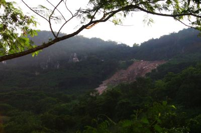
the desecrated side of Mt. Manalmon blasted away by dynamite in search of the precious marble

a river runs thorough it
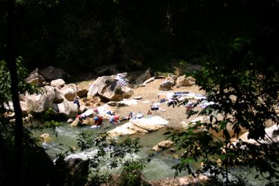
aren't people supposed to stay out of protected reserve? even washing their clothes can ruin the water...tsk...tsk...tsk

a shoud've been nice photo if not for the bad lighting :(

the bat cave. wait until 5pm for the friends of the Dark Knight to come out
Continued here.
Bulacan Resorts
Labels: Bulacan, Caves, Central Luzon, Emilio Aguinaldo, Filipino-American War, History, National Parks
posted by GingGoy @ 8:44 PM,
,