Southern Leyte's Agas-agas Bridge Beckons Bungee Jumping, Extreme Sports
22 September 2009
An engineer and avid fan of megastructures, Tutubi was able to cross San Juanico Bridge, the longest bridge in the country connecting the islands of Samar and Leyte, even in the middle of heavy rains.
This time, he went off to check for himself the newly-opened bridge in Leyte Island in the town of Sogod. This he did by canceling an earlier planned trip to Sohoton Cave in Basey, Samar across Leyte Gulf.
 Agas-agas Bridge from one end of the viaduct. Note the bahay kubo (native huts) below to add scale
 The two piers supporting the bridge with a height of 292 feet visible on this photo. The platform on the sides of the bridge made available another bungee jumping in the Philippines' Eastern Visayas region
Recently inaugurated by PGMA, Agas-agas bridge was constructed to address the safety issues of frequent landslides and erosion in the area particularly during heavy rains and typhoons. I was funded by the Japanese government through the Official Development Assistance (ODA) fund and construction supervised by Sumitomo Mitsui Construction Co. of Japan.
 a "side view" of the bridge taken from the old dangerous road it replaced
 The tallest Bridge in the Philippines lies at kilometer 1007 marker and only habal-habal (motorcycle taxis) are available as public transportation from Mahaplag, Leyte or Sogod, Southern Leyte
With huge potential as an adventure tourism destination, made a part of the 350 meter long viaduct is a platform specifically for bungee jumping enthusiasts. Aficionados of other extreme sports like paramotor, downhill skateboarding zipline and rapelling are also expected to visit the Philippines highest bridge.
 DPWH Agas-agas Bridge Field Office with ample parking space for possible adventurers to park their vehicles
 (right picture: the two huts in the green valley below the bridge with a small waterfall in view, part of the Leyte Mountain Trail)
Tutubi wasn't able to see or experience any extreme sports at Agas-agas but on his return to Dulag, Leyte that he realized that he was able to set foot on the province of Southern Leyte.
How to get there:
Don't even think of commuting to Agas-agas bridge for for there's no public transportation that pass by the route except the hardy habal-habal. Mahaplag is a town of Southern Leyte and can be reached after about two hours travel from Tacloban City, about 70 kilometers away via zig-zag roads cutting through the beautiful landscapes of the so-called Leyte Mountain Trail. The bridge is located at the kilometer 1007 marker.
Related Posts:
The Longest Bridge of the Philippines
This time, he went off to check for himself the newly-opened bridge in Leyte Island in the town of Sogod. This he did by canceling an earlier planned trip to Sohoton Cave in Basey, Samar across Leyte Gulf.
 Agas-agas Bridge from one end of the viaduct. Note the bahay kubo (native huts) below to add scale
 The two piers supporting the bridge with a height of 292 feet visible on this photo. The platform on the sides of the bridge made available another bungee jumping in the Philippines' Eastern Visayas region
Recently inaugurated by PGMA, Agas-agas bridge was constructed to address the safety issues of frequent landslides and erosion in the area particularly during heavy rains and typhoons. I was funded by the Japanese government through the Official Development Assistance (ODA) fund and construction supervised by Sumitomo Mitsui Construction Co. of Japan.
 a "side view" of the bridge taken from the old dangerous road it replaced
 The tallest Bridge in the Philippines lies at kilometer 1007 marker and only habal-habal (motorcycle taxis) are available as public transportation from Mahaplag, Leyte or Sogod, Southern Leyte
With huge potential as an adventure tourism destination, made a part of the 350 meter long viaduct is a platform specifically for bungee jumping enthusiasts. Aficionados of other extreme sports like paramotor, downhill skateboarding zipline and rapelling are also expected to visit the Philippines highest bridge.
 DPWH Agas-agas Bridge Field Office with ample parking space for possible adventurers to park their vehicles
 (right picture: the two huts in the green valley below the bridge with a small waterfall in view, part of the Leyte Mountain Trail)
 Tutubi wasn't able to see or experience any extreme sports at Agas-agas but on his return to Dulag, Leyte that he realized that he was able to set foot on the province of Southern Leyte.
How to get there:
Don't even think of commuting to Agas-agas bridge for for there's no public transportation that pass by the route except the hardy habal-habal. Mahaplag is a town of Southern Leyte and can be reached after about two hours travel from Tacloban City, about 70 kilometers away via zig-zag roads cutting through the beautiful landscapes of the so-called Leyte Mountain Trail. The bridge is located at the kilometer 1007 marker.
Related Posts:
The Longest Bridge of the Philippines
Labels: Adventure Tourism, Bridges, Eastern Visayas, Southern Leyte
posted by GingGoy @ 9:09 PM,
,
![]()
![]()
The Historic Bell House, Camp John Hay, Baguio City
16 September 2009
Posted in celebration of Baguio City's 100th year anniversary as a chartered city last September 9, 2009.
Walking distance from The Manor Hotel and inside the Historic core of Camp John Hay is the charming Bell house, the original vacation home of the Commanding General of the Philippines. It was named after General J. Franklin Bell who's credited for transforming Camp John Hay into a major military resort.
 Bell House, historic vacation home, surrounded by a nice manicured garden and pine trees at Camp John Hay Historical Core

 The seal of Camp John Hay, used to be displayed at the main gate, marking more than 100 years of existence from 1903
The Bell House of today currently serves as a museum of American colonial architecture and lifestyle. A portrait of John Milton Hay is displayed in the living room, complete with a fireplace, while the walls narrate Camp John Hay history through various images.

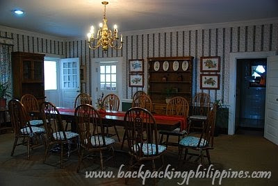 the dining room displaying lifestyle of American commanding general
At one corner of the vacation home stands a totem pole with descriptive plaque that states:
"Carved by Ernesto Dul-ang, a succession of historical figures during the first half of the 20th century form a totem pole that once looked out on top of Scout Hill
Admiral George Dewey led the Battle of Manila Bay
General Emilio Aguinaldo was the first president of the Republic of the Philippines
President William Howard Taft was the first governor-general of the Philippines and later Secretary of War took a great interest in the development of Baguio City and Camp John Hay
Secretary John Milton Hay was secretary of state when the Philippines became a colony of the United States. He died as the construction of the camp named in his honor went into full gear.
William Cameron Forbes was a governor-general of the Philippines who is credited with the development of Baguio City
President Theodore Roosevelt signed the order that designated 535 acres as the military reservation that became Camp John Hay
Major General Franklin Bell was commander of the Philippines department and designer of Italian Garden as well as Bell House and Amphitheater
Lt. Col. Lyman W. Kennon oversaw the completion of the road that facilitated the construction and development of Baguio City and Camp John Hay
Mayor James Halsema was the last American Mayor of Baguio City
General Douglas McArthur was the famous liberator of the Philippines during World War II"
Near the historic Bell house is the Bell Amphitheater, a favorite venue for weddings, debuts, parties and other events.

The Bell House and Amphitheater are not just tourist attractions in Baguio City but also has historical and heritage significance that should be preserved for posterity.
Interesting Places near Bell House and inside Camp John Hay:
The Manor Hotel
Cemetery of Negativity
How to get there:
The best way to get there is via a taxi from Baguio CBD/Session Road as public transportation (jeepneys) don't enter the former military camp (unless you love to do lots of walking)
Walking distance from The Manor Hotel and inside the Historic core of Camp John Hay is the charming Bell house, the original vacation home of the Commanding General of the Philippines. It was named after General J. Franklin Bell who's credited for transforming Camp John Hay into a major military resort.
 Bell House, historic vacation home, surrounded by a nice manicured garden and pine trees at Camp John Hay Historical Core
 The seal of Camp John Hay, used to be displayed at the main gate, marking more than 100 years of existence from 1903
The Bell House of today currently serves as a museum of American colonial architecture and lifestyle. A portrait of John Milton Hay is displayed in the living room, complete with a fireplace, while the walls narrate Camp John Hay history through various images.

 the dining room displaying lifestyle of American commanding general
At one corner of the vacation home stands a totem pole with descriptive plaque that states:

"Carved by Ernesto Dul-ang, a succession of historical figures during the first half of the 20th century form a totem pole that once looked out on top of Scout Hill
Admiral George Dewey led the Battle of Manila Bay
General Emilio Aguinaldo was the first president of the Republic of the Philippines
President William Howard Taft was the first governor-general of the Philippines and later Secretary of War took a great interest in the development of Baguio City and Camp John Hay
Secretary John Milton Hay was secretary of state when the Philippines became a colony of the United States. He died as the construction of the camp named in his honor went into full gear.
William Cameron Forbes was a governor-general of the Philippines who is credited with the development of Baguio City
President Theodore Roosevelt signed the order that designated 535 acres as the military reservation that became Camp John Hay
Major General Franklin Bell was commander of the Philippines department and designer of Italian Garden as well as Bell House and Amphitheater
Lt. Col. Lyman W. Kennon oversaw the completion of the road that facilitated the construction and development of Baguio City and Camp John Hay
Mayor James Halsema was the last American Mayor of Baguio City
General Douglas McArthur was the famous liberator of the Philippines during World War II"
Near the historic Bell house is the Bell Amphitheater, a favorite venue for weddings, debuts, parties and other events.

The Bell House and Amphitheater are not just tourist attractions in Baguio City but also has historical and heritage significance that should be preserved for posterity.
Interesting Places near Bell House and inside Camp John Hay:
The Manor Hotel
Cemetery of Negativity
How to get there:
The best way to get there is via a taxi from Baguio CBD/Session Road as public transportation (jeepneys) don't enter the former military camp (unless you love to do lots of walking)
Labels: Baguio City, Benguet, Cordillera Administrative Region, History, Museums
posted by GingGoy @ 9:15 PM,
,
![]()
![]()
Manila Cebu Ferries Promo Fares, Schedules, Routes
11 September 2009
Just to post information on the latest Cebu Ferries Promo Fare servicing the following ferry route either fast craft or ordinary ferry)
Tutubi was able to board and ride in one of Cebu Ferries ferry overnight from Cebu to Cagayan de Oro in 2003 then another one in 2004 from Dumaguete to Cebu
Cebu Ferries Routes and destinations:
Cebu - Butuan City, Nasipit
Cebu - Cagayan de Oro
Cebu - Dumaguete City
Cebu - Dipolog City
Cebu - Iligan City
Cebu - Manila
Cebu - Ormoc City, Leyte
Cebu - Ozamiz City
Cebu - Surigao City, Surigao del Norte
Cebu - Zamboanga City
How much is the ferry fare from Cebu or Manila? You may book your trip and buy tickets at
http://www.2go.com.ph as they're the operator now of Cebu Ferries, along with Negros Navigation, Supercat and SuperFerry brands (Review Cebu Ferries food)
you may book online or buy at cheap ticket prices from 2Go Travel Ferry outlets and business centers
Labels: Ferries
posted by GingGoy @ 11:00 PM,
,
![]()
![]()
A Rainy Day at Dambana ng Kagitingan (Shrine of Valor), Mt. Samat Bataan
09 September 2009
"Bumagsak na ang Bataan," Tutubi said when he went to Bataan to attend his officemates' wedding at St. Joseph Cathedral in Balanga with a sidetrip to the historic Mt. Samat, the site of fierce fighting at the onset of World War II and where the Dambana ng kagitingan (Shrine of Valor) stands to remind visitors of the gallant stand of American and Filipino soldiers in World War II.
Mt. Samat was the stronghold of combined American and Filipino forces defending the mountainous peninsula of Bataan against the Japanese from December 1941 until its capitulation on April 9, 1942.
The almost four month long resistance, caught the Japanese by surprise and delayed their war plan thereby saving Australia from the onslaught of the Land of the Rising Sun.
The Fall of Bataan on April 9, 1942 started the harrowing war crime called Bataan Death March where thousands of American and Filipino POWs were forced to march for about 100 kilometers, by foot interrupted by a train ride in cramped cars, for days without food and water to get to Capas, Tarlac. Thousands died during the ordeal and thousands more died at the concentration camp during captivity.
 Mt. Samat Shrine, dubbed "Dambana ng Kagitingan (Shrine of Valor)," was built to honor not just the heroic efforts of the World War II soldiers who valiantly fought the Japanese invaders against insurmountable odds but also all other heroes whose heroics and deeds were enshrined like Jose Rizal whose bas relief occupies one side of the Memorial Cross, Juan Luna, Emilio Aguinaldo, Lapu-Lapu, Apolinario Mabini, Emilio Jacinto, Melchora Aquino, Gabriela Silang et al.
Now declared a National Historical Shrine, it was built during the time of Pres. Ferdinand Marcos on top of Mt. Samat, the base of the site of fierce fighting with main feature of a Monument Cross standing 92 meters tall made of concrete, marble and steel.
The hurriedly taken picture of Dambana ng Kagitingan's Monument Cross in just in time before fog and rain enveloped the monument
 a brief lull in the rain allowed Tutubi to take a photo of two "young-at-hearts" playing with a gun battery similar to the ones displayed on Corregidor Island
 The sad part about the trip was that the rain almost spoiled the trip completely. Tutubi didn't bother to ride the elevator to get to the top of the Monument Cross to get a sweeping view of Bataan peninsula, Manila Bay and even Corregidor Island. A brief photo-op with officemates resulted to a few pictures (with one of his peers did an Oblation-like pose near the cross' base in silhouette). No other pictures were taken as the entire Mt. Samat was covered in rain clouds that even Tutubi's waterproof camera was rendered useless.
Dambana ng Kagitingan deserves a return trip for Tutubi as well as his wish to re-trace the infamous Death March route someday.
---
Dambana ng Kagitingan Travel Information
Mt. Samat Shrine Entrance Fees:
PhP30.00 for foreigners
PhP20.00 for locals
PhP10.00 for students
Parking fee:
PhP20.00 cars/small vehicles
PhP50.00 large vehicles
Overnight accommodations at Mt. Samat Shrine is offered at the Dambana ng Kagitingan Guesthouse. No information was gathered due to the rains.
There's also a museum inside the shrine but was not visited by Tutubi due to lack of time.
Shrine is open to the public from 8am to 5pm, Tuesdays to Sundays (closed on Mondays, no information on holidays as of posting time). Elevator access to the top of the Cross is closed during lunch break
Comfort Rooms available with PhP3.00 per "pee fee."
How to get to Mt. Samat Shrine Bataan:
Driving Directions: From EDSA northbound to Balintawak take NLEX and exit at the SCTEx spur road after passing Dau toll plaza. After getting ticket at SCTex tollgate, choose the road going to Subic and exit at Dinalupihan (Toll fee: PhP88.00) Turn right at the end of the SCTEx exit road and follow road signs leading to Mt. Samat, Balanga or your destination town.
On reaching Pilar, Bataan junction, you'll see direction signs on your right pointing the way to Mt. Samat where you turn right (sign says the historic shrine is 11 kilometers away). Turn left on the road after passing Kilometer 19 Death March Marker
Travel time to Bataan (Mt Samat or Balanga) is around 2.5 to 3 hours from EDSA, Quezon City via NLEX and SCTEx.
Commute to Bataan, the backpacking way is not easy for the route to the historic shrine is not served by public transportation. The nearest point can be reached by Bataan buses is the Pilar, Bataan junction on the national highway where the shrine's 11 kilometers away. You can ride a tricycle at the junction or do some muscle flexing by trekking up the mountain.
Ferries to Bataan are available from SM Mall of Asia complex by MetroStar serving the Pasay to Orion Port ferry route. In Orion, you can ride jeepneys going to Balanga that pass by Pilar and alight at the junction for the jump-off point to Mt. Samat Shrine
Labels: Bataan, Central Luzon, Historical Shrines, World War II
posted by GingGoy @ 9:09 PM,
,
![]()
![]()
Ferdinand Magellan Did NOT Discover The Philippines; Capt. James Cook Did NOT Discover Australia
05 September 2009
Who discovered Australia and when? A question posed by an Australian tour guide at the Blue Mountains to a group of tourists where an American replied "Capt. James Cook in 1778."
The Australian tour guide shook his head in disbelief and said that indeed Capt. James Cook arrived in 1770, not 1778, in Australia, but it would be disrespectful to the Aborigines to say he discovered the island for the Aborigines already discovered Australia thousands of years before the white men came to the land of kangaroos, emus, platypuses, koalas and wombats.
The answer of the Australian tour guide to his own question was concurred by Tutubi in that back home in his beloved Philippine Islands, most Philippine history books still erroneously state that on March 17, 1521 Ferdinand Magellan "discovered" the Philippines.
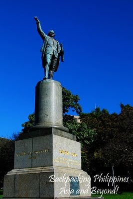 Tutubi stumbled upon Capt. James Cook monument at Hyde Park located near his hotel in Sydney CBD
The Australian aborigines arrived in Australia way before the British
came and so deserve credit for the discovery; the English merely arrived
in Australia in 1770.
 The monument honors the "discoverer" of Australia with the iconic Sydney Tower in the background
On the same note, the little black people, the aborigines of the
Philippines called Aeteas or Negritos, settled on the islands way before the Austronesians, the ancestors of modern Filipinos, came from Taiwan, before they spread out to the nearby islands of Indonesia, Malaysia, Timor Leste, Micronesia, Polynesia, Hawaii and even as far as Madagascar on the east coast of Africa.
How could the Portuguese navigator in the service of Spain have "discovered" the islands that he named San Lazaro, later to be called The Philippines, when people were already living on the various islands? When the Chinese, Vietnamese, Indians and other Asian countries were already trading goods with pre-hispanic Filipinos; when Maynila, was already a thriving city ruled by a vassal of Brunei; when Cebu and Mactan were ruled by the warring Rajah Humabon and Lapu-lapu respectively.
To the eyes of the European, Ferdinand Magellan may have "discovered" the Philippines for them, but it's not right for a FIlipino to say Magellan discovered Philippines for he merely arrived in these islands in 1521.
History needs to be re-written to reflect the perspective of the locals and not of the Europeans who think they discovered and later colonized most of the world.
Times have changed and so must your view of history.
Labels: Australia, Beyond Asia, History, Sydney
posted by GingGoy @ 10:31 PM,
,
![]()
![]()
Fort Drum is to Subic Bay, Fort Denison is to Sydney Harbour
01 September 2009
Corregidor Island is to Manila bay, Fort drum (El Fraile Island) is to Subic Bay, Fort Denison Island is to Sydney Harbour.
Fort Denison is a former prison turned into a park at the entrance of Sydney Harbour acting as a strategic forward fort and defense outpost in Sydney Harbour. It can be seen from the Sydney Harbour Bridge, Sydney Opera House or Mrs McQuarries Chair but the closest view Tutubi got was on board the ferry to Taronga Zoo.

The Rock of Sydney: Fort Denison
Guided tours of Fort Denison can be booked at Circular Quay where you can actually walk on the fort and explore the lighthouse, cannons and fortifications.

Fort Denison against Sydney skyline (notice the iconic Sydney Tower)
There's an age-old practice of firing a cannon at 1pm every day, some sort of time synchronization with sailors of yore, that continues up to this day.
How to get to Fort Denison, Sydney Harbour:
Ferries to Fort Denison depart wharf 6 at Circular Quay at regular intervals everyday. Ticket price for the ferry ticket includes guided tour of the fort.
Labels: Australia, Beyond Asia, Sydney
posted by GingGoy @ 9:51 PM,
,
![]()
![]()