Baluarte: The Leaning Watchtower of Luna, La Union
22 September 2011
Several baluartes (watchtowers) can be found on the coast of Ilocos Norte, Ilocos Sur and La Union built by the Spanish authorities to guard and warn coastal communities of any suspicious ship coming to shore and thus warn people of impending danger from marauders, usually Moro or Chinese pirates slave traders, snatching young girls and women during summer. The watchtowers were mostly constructed about 400 years ago, made of adobe blocks and coral stones joined by lime and egg whites, typical construction styles of Spanish churches.
 Watchtowers: the sentinels of the sea against marauding pirates and unwelcome visitors
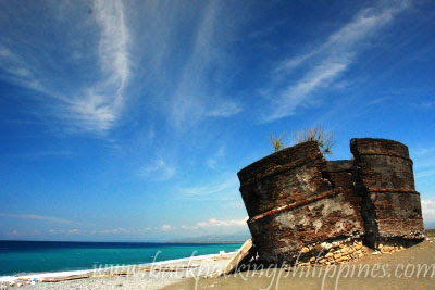
Tutubi already visited and posted several of the watchtowers and this one, located in the town of Luna, La Union (formerly called Namacpacan and now named after one of the towns famous sons, Gen. Antonio Luna (brother of Juan Luna)) is no different but in such sad and forlorn state, just waiting for a strong typhoon, tsunami or apathetic humans to topple it down to oblivion. The watchtowers foundation is already eroded probably due to seepage of seawater making it look like the leaning Luna watchtower that urgently needs restoration, if there are still people out there who appreciate heritage.
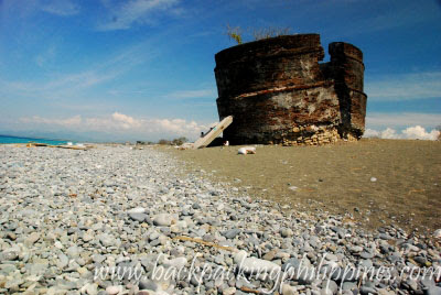 the ruins of the Luna Watchtower sits on a pebble beach, where people make a living of gathering pebbles to be sold to traders and exporters of white, gray or sometimes colored pebbles for use in landscaping, construction and aquariums here in abroad
 the leaning watchtower, held in check by crude wooden planks, children nearby add scale to the photograph
 the watchtower has been split in two due to cracked foundation and a tree further poses risking damage to the heritage structure
Other baluartes in La Union province can be found in Carlatan, San Fernando (a small town formerly known as Pindangan), Balaoan, Bacnotan and San Juan, all yet to be visited by Tutubi.
---
Luna Watchtower,
Barangay Victoria, Luna, La Union
GPS Coordinates: N16 51 24.8 E120 22 22.0
Related Posts:
Bateria Watchtower
Santa Watchtower
La Union Beach Resorts
 Watchtowers: the sentinels of the sea against marauding pirates and unwelcome visitors
Tutubi already visited and posted several of the watchtowers and this one, located in the town of Luna, La Union (formerly called Namacpacan and now named after one of the towns famous sons, Gen. Antonio Luna (brother of Juan Luna)) is no different but in such sad and forlorn state, just waiting for a strong typhoon, tsunami or apathetic humans to topple it down to oblivion. The watchtowers foundation is already eroded probably due to seepage of seawater making it look like the leaning Luna watchtower that urgently needs restoration, if there are still people out there who appreciate heritage.
 the ruins of the Luna Watchtower sits on a pebble beach, where people make a living of gathering pebbles to be sold to traders and exporters of white, gray or sometimes colored pebbles for use in landscaping, construction and aquariums here in abroad
 the leaning watchtower, held in check by crude wooden planks, children nearby add scale to the photograph
 the watchtower has been split in two due to cracked foundation and a tree further poses risking damage to the heritage structure
Other baluartes in La Union province can be found in Carlatan, San Fernando (a small town formerly known as Pindangan), Balaoan, Bacnotan and San Juan, all yet to be visited by Tutubi.
---
Luna Watchtower,
Barangay Victoria, Luna, La Union
GPS Coordinates: N16 51 24.8 E120 22 22.0
Related Posts:
Bateria Watchtower
Santa Watchtower
La Union Beach Resorts
Labels: Ilocos Region, La Union, Watchtowers
posted by GingGoy @ 8:42 PM,
,
![]()
![]()
Gabriela Silang Park, Santa, Ilocos Sur (Northern Luzon Heroes Hill National Park)
20 September 2011
Tribute post to Gabriela Silang's 248th death anniversary
Just along the national highway in the town of Santa, Tutubi chanced upon a billboard marking the historic pass occupied by Ilocano fighters under the command of Diego Silang, then later succeeded by his wife Gabriela.
Gabriela Silang Park occupies a strategic location overlooking the sea on a promontory, beside Imelda Park (yeah, listed as a tourist attraction in Ilocos Sur website but actually badly maintained with very few people, mostly locals, present).
What can you see in Gabriela Silang Memorial Park? Just a billboard, empty tables and benches for picnics, there's Imelda Park, also with picnic tables (mostly empty), beach nearby, huge trees (probably centuries old or at least heritage ones 50 years or more) and across the highway is Northern Luzon Heroes Hill National Park


a marker nearby states (in Filipino): "dating Pideg at ginawang Diego - Gabriela Silang noong 1976. Ipinagawa ng mga Pransiskano noong 1600. Ginamit noong 1600 sa pag-aalsa nina Andres Malong at nina Diego at Gabriela noong 1762 pagkamatay ni Diego noong May 28, 1763. Ang pag-aalsa ay pinamunuan ni Gabriela, pagkaraan ng ilang sagupaan as sinalakay ng mga kastila and pasong ito. Nadakip si Gabriela at ipinabitay noong setyemre 20, 1763"
The Gabriela Silang Monument near the entrance of Imelda Park (in silhouette) due to late afternoon stop by Tutubi, with the heroine astride on a horse.

 the Gabriela Silang Monument at Gabriela Silang Carpark at the corner of Makati Avenue and Ayala Avenue, Makati City
Have you ever wondered if it's really correct to depict Gabriela Silang on a horse with two feet off the ground? Monuments with persons on a horse have meanings :P
---
Location: Santa, Ilocos Sur
GPS Coordinates: N17 27 53.0 E120 26 06.2
Labels: Ilocos Region, Ilocos Sur, National Heroes, Parks, Philippine History
posted by GingGoy @ 8:42 PM,
,
![]()
![]()
EDSA: History, Highway 54, Skyway Project and Trivia
19 September 2011
EDSA, named after Epifanio delos Santos, is Metro Manila's main thoroughfare stretching around 24 kilomters from Caloocan City in the north, to Pasay City down south.
This is just a quick post on the real story behind Highway 54, the old name of the historic avenue known today as EDSA.
EDSA Trivia:
Named after Epifanio de los Santos: a historian, jurist, artist, literary critic, and scholar from Malabon.
Construction started in the 1930s under Pres. Manual L. Quezon and initially called North-South Circumferential Road.
Renamed Avenida 19 de Junio for Jose Rizal’s birthday in 1946,
Renamed Highway 54 in the 1950s.
Renamed Epifanio de los Santos Avenue (EDSA) on April 7, 1959 by virtue of Republic Act No. 2140.
 Picture of EDSA corner Ortigas Avenue from EDSA Shrine, no MRT yet, in 1990. Photo Credits to unknown photographer.
Why was EDSA formerly called Highway 54?
Answers:
Some people say it's because EDSA is 54 kilometers to which no truth to the claim (or probably the government indicated 54 kilometers on the contract price but actually built 24 kilometers, pocketed the cost of the 20 kilometers (missing miles) :) while some say because there were 53 other roads constructed before it.
According to Arch. Felino Palafox (asked by Tutubi at an Urban Planning talk sponsored by BAIPHIL some time ago), it was called Highway 54 mainly because it was built in 1954 and is generally 54 meters wide (but still Tutubi's not convinced)
However this one came out in the comments section which has some truth in it: "The road was named Highway 54 to pay tribute to the men that built it - the 54th Army Engineering Brigade led by engineers Florencio Moreno and Osmundo Monsod. It was completed in 1940 (not in 1954) under the presidency of Pres. Manuel L. Quezon."
Highway 54 is also a commercial building in front of SM Megamall in Mandaluyong, the home of Hway Cafe, St. Augustine School of Nursing and other establishments.
How long is EDSA in kilometers?
It's about 24 kilometers in length. Note: Tutubi travels EDSA from Munoz (COngressional Avenue/Roosevelt Avenue in Quezon City) to Sen. Gil Puyat Avenue in Makati regularly and knows that the stretch is around 12 kilometers. Add the distance of Munoz to Monumento plus Buendia to Roxas Boulevard and you'll be complete (unless you also add the extension going to SM Mall of Asia (MOA))
How about the planned second level EDSA Skyway?
It's a planned second level on top of the old EDSA being studied by the Department of Public Works and Highways (DPWH) for 2012 budget. Either a second level road or a SMART tunnel to double as a flood water collector. Just what EDSA needs as road widening is impractical. Proposed start of construction is next year but will be finished far beyond president Aquino's term.
Are there alternative route to EDSA going from QC to Makati?
C5 is one but for me, I take Araneta Avenue, N. DOmingo, Blumentritt then the inner circuitous roads of San Juan going to Maysilo, Mandaluyong, to Makati Avenue.
Last tip from Tutubi:
to Monitor EDSA traffic, here's a live traffic monitoring system by the Metropolitan manila Development Agency (MMDA). Tutubi uses it for months now and quite accurate.
---
EDSA trivia, EDSA history, EDSA facts, EDSA total length, how long is EDSA, EDSA traffic
This is just a quick post on the real story behind Highway 54, the old name of the historic avenue known today as EDSA.
EDSA Trivia:
Named after Epifanio de los Santos: a historian, jurist, artist, literary critic, and scholar from Malabon.
Construction started in the 1930s under Pres. Manual L. Quezon and initially called North-South Circumferential Road.
Renamed Avenida 19 de Junio for Jose Rizal’s birthday in 1946,
Renamed Highway 54 in the 1950s.
Renamed Epifanio de los Santos Avenue (EDSA) on April 7, 1959 by virtue of Republic Act No. 2140.
Why was EDSA formerly called Highway 54?
Answers:
Some people say it's because EDSA is 54 kilometers to which no truth to the claim (or probably the government indicated 54 kilometers on the contract price but actually built 24 kilometers, pocketed the cost of the 20 kilometers (missing miles) :) while some say because there were 53 other roads constructed before it.
According to Arch. Felino Palafox (asked by Tutubi at an Urban Planning talk sponsored by BAIPHIL some time ago), it was called Highway 54 mainly because it was built in 1954 and is generally 54 meters wide (but still Tutubi's not convinced)
However this one came out in the comments section which has some truth in it: "The road was named Highway 54 to pay tribute to the men that built it - the 54th Army Engineering Brigade led by engineers Florencio Moreno and Osmundo Monsod. It was completed in 1940 (not in 1954) under the presidency of Pres. Manuel L. Quezon."
Highway 54 is also a commercial building in front of SM Megamall in Mandaluyong, the home of Hway Cafe, St. Augustine School of Nursing and other establishments.
How long is EDSA in kilometers?
It's about 24 kilometers in length. Note: Tutubi travels EDSA from Munoz (COngressional Avenue/Roosevelt Avenue in Quezon City) to Sen. Gil Puyat Avenue in Makati regularly and knows that the stretch is around 12 kilometers. Add the distance of Munoz to Monumento plus Buendia to Roxas Boulevard and you'll be complete (unless you also add the extension going to SM Mall of Asia (MOA))
How about the planned second level EDSA Skyway?
It's a planned second level on top of the old EDSA being studied by the Department of Public Works and Highways (DPWH) for 2012 budget. Either a second level road or a SMART tunnel to double as a flood water collector. Just what EDSA needs as road widening is impractical. Proposed start of construction is next year but will be finished far beyond president Aquino's term.
Are there alternative route to EDSA going from QC to Makati?
C5 is one but for me, I take Araneta Avenue, N. DOmingo, Blumentritt then the inner circuitous roads of San Juan going to Maysilo, Mandaluyong, to Makati Avenue.
Last tip from Tutubi:
to Monitor EDSA traffic, here's a live traffic monitoring system by the Metropolitan manila Development Agency (MMDA). Tutubi uses it for months now and quite accurate.
---
EDSA trivia, EDSA history, EDSA facts, EDSA total length, how long is EDSA, EDSA traffic
Labels: Metro Manila, Roads and Highways
posted by GingGoy @ 9:41 PM,
,
![]()
![]()
PVP Liner Bus to Ayala Avenue, Makati from SM San Lazaro, Manila
PVP Liner once served commuters to Ayala Avenue, Makati coming from Sampaloc, Manila, this is the route of PVP Liner bus from España via Nagtahan. They stopped operating the route when Mayor Erap demanded only buses with bus terminals in Manila can enter the city.
AS of posting time, PVP Liner resumed operation but bus terminal now at SM San Lazaro and pass by Taft Avenue to Buendia (Gil Puyat), turns right to Makati Avenue and turn right to Ayala Avenue then back to SM San Lazaro via Gil Puyat and Taft Avenue
UPDATE: August 8, 2016
PVP Liner STOPPED operations after Manila bus ban of Mayor Erap, PVP Liner probably doesn't have a bus terminal at P. Noval corner Espana
Bus fare to Ayala Avenue from España: PhP25.00
From P. Noval St. corner España, Sampaloc, Manila (UST) is located the PVP Liner bus waiting for passengers.
The bus will turn left to España, right to A.H. Lacson (formerly Gov. Forbes),
pass Nagtahan Bridge, onwards to Quirino Highway,
left to Sen. Osmena Highway (linked to SLEX)
left to Sen. Gil Puyat Avenue (formerly Buendia, area known as Mayapis, near the PNR train station), cross Pasong Tamo and Ayala Avenue (landmarks: Makati Medical Center, Crispa, Makati Post Office),
right to Makati Avenue (landmarks: Petron, Pacific Star Building, Development Bank of the Philippines (DBP), Manila Mandarin Hotel), right to Ayala Avenue (The Peninsula Hotel, Shangri-la Hotel, Makati Stock Exchange, Ayala Triangle, Tower One),
cross Paseo de Roxas (The Enterprise Center, Bank of the Philippine Islands, Insular Life Building, Philamlife Tower) cross V.A. Rufino St (formerly Hererra St, landmarks: Rufino Tower, PBCOM, Smart Tower) cross Leviste St/Salcedo St (landmarks: GT Tower),
cross Sen. Gil Puyat Avenue (landmarks: RCBC towers), pass around Zuellig Loop (The Columns) then goes back to España via the earlier described route to A.H. Lacson, left turn to Dapitan St then bak to P. Noval St or straight to Quiapo.
Note: PVP liner also has routes from Quiapo, to Taft Avenue, Bautista then Sen. Gil Puyat Avenue
in the morning, there are numerous corners in Sampaloc where you can see queues of people waiting for shuttle buses, gt express or colorum lines.
EDSA buses with signboard Ayala/LRT turn right to Ayala from EDSA, up to Buendia, Zuelling Loop then Sen. Gil Puyat up to LRT and Leveriza. The Ayala/Ibabaw buses just pass by EDSA and Ayala Avenue intersection and drop off passengers under MRT Ayala Station
Labels: Buses, Public Transportation
posted by GingGoy @ 8:29 PM,
,
![]()
![]()
Babalu's Bulalo (Mis)Adventures in San Fernando, La Union
07 September 2011
Along the way in every trip, you'll always encounter something unusual, something that captures your fancy by just looking at road signs and establishment names.
One sign caught Tutubi's attention with the sign that proudly say "babalu's bulalo" somewhere in Tarlac and another in Bauang, La Union with a restaurant serving steaming hot bulalo (beef marrow soup) along the highway and where you can see lots of parked cars, meaning it must be good, cheap or both.
But since seeing Babalu's Bulalo and not yet time for lunch, Tutubi and his driver drove on and just looked for a place to eat out at 12 noon along the bypass road of San Fernando, Union, a place called Sisters Restaurant with a signage advertising bulalo on their menu.
 the simple menu of the simple roadside eatery in San Fernando, La Union says: bagisen, papaitan, sinanglao, cowballs (soup #5?)
Without thinking, Tutubi ordered bulalo plus "bistek" for his companion to satiate his craving for his favorite comfort food. But to his dismay, he got this: bulalong pata ng baboy, more like nilagang baboy.
 bulalo...err...nilagang pata ng baboy
Was Tutubi misled by the bulalo sign outside or he's totally clueless that in La Union, bulalo means pork knuckle soup?
On his return trip to Sta. Cruz, Ilocos Sur, he again passed by the same road, saw the same restaurant with the unforgettable "bulalo" but no longer duped and instead was able to mark the real Babalu's Bulalo in his GPS so as not to miss it. The result:
 Babalu's Bulalo branch in Bauang, La Union (an order costs PhP50.00 single serving)
Besides finally sampling Babalu's Bulalo, he was also able to find out if the "long-chin" actor was behind the road side bulalo eatery but he got the answer that Babalu was really not behind the restaurant, it's just a marketing ploy, some sort of name recall that even Tutubi was fooled.
Babalu's Bulalo falls into the Frugal Food Find category, bulalo was not really good but also not bad at a price of PhP50.00. It seems the marrowy goodness of beef tendons got drowned out by the generous serving of soup but still it's something to satiate once craving for hot bulalo, particularly for the ultra-hungry on rainy days.
Labels: Filipino Cuisine, Frugal Food Find, La Union
posted by GingGoy @ 9:39 PM,
,
![]()
![]()
Tinubong: Kakanin Inside Bamboo Tubes in Vigan, Ilocos Sur
01 September 2011
Another Ilocos delicacy, besides Candon Kalamay, peddled on the streets of Vigan is the tinubong, so called as it derives its name from the container, a bamboo tube with an opening at one end and a node at the other, which locals (Ilocano) call tubong, thus the name tinubong. The tinubong comes stuffed inside bamboo poles of about an inch or two in diameter and about a foot in length.
 Tinubong beside Candon Kalamay offered by hawkers outside Baluarte
Tinubong is a sticky, sweet delicacy made from glutinous flour, sugar, coconut milk, small strips of buko (young coconut flesh) and sometimes cheese and margarine inserted into the bamboo tube then roasted over charcoal embers (traditionally) or in ovens (in commercial quantities).
 tinubong with the sweet stuff exposed when you split the bamboo tube.
You can buy tinubong sold by peddlers, near the Baluarte, city plazas, and other Vigan pasalubong shops in the old heritage city for about PhP20.00 per tube depends on size and your haggling skills.
Related Posts:
Royal Bibingka
Candon Kalamay
Vigan Longganisa
Hidden Garden
Labels: Delicacies, Ilocos Region, Ilocos Sur, Vigan
posted by GingGoy @ 8:55 PM,
,
![]()
![]()
Chavit Singson's Baluarte in Vigan/Caoayan, Ilocos Sur
Just to post about Tutubi's 20 minute visit to Chavit Singson's Baluarte in Vigan (actually part of Caoayan town of Ilocos Sur) before heading the long drive home.
Baluarte is becoming famous stopover for tourists visiting Vigan where people can see and interact with animals on display at the Chavit Singson's mansion cum mini-zoo, with animal interaction scheduled everyday with several wild animals (better left in the wild, Tutubi thinks) . Animals kept at the mini-zoo include pygmy horses, white deers, camels, tigers, various birds, ostriches, and snakes.
 Chavit Singson's Balwarte in Caoayan, Ilocos Sur
 a dromedary (arabian camel with a single hump) shot around high noon
 a pair of white deers resting in the noon shade
After taking a few pictures, Tutubi sped off to Sta. Cruz town then went home.
---
Baluarte Show Schedules
Animal encounters
everyday 11am, 12nn, 4pm
Potbelly Painting: daily at 10am and 2pm
baluarte entrance fee/admission price: none, nada, gratis, free
parking: ample parking spaces, no parking fee
photography: no restrictions, no permits required to shoot
How to get to Baluarte, Caoayan, Ilocos Sur:
From Vigan city proper, just hire a tricycle to take you there, travel time is about 10 minutes. Consider asking tricycle driver to wait for you or pick you up at an appointed time
If you have your own car, just drive down inwards on Quirino Avenue (the street of Petron gas station on the highway) until you see the Caoayan welcome arch where you turn right (on the fork). Drive until you see the Baluarte artwork then choose the right fork (if you missed it and chose left, you'll end up at the Hidden Garden of Vigan)
Coordinates: N17 33 02.1 E120 22 39.1 (useful if you have GPS navigator).
Open Street Map here (trivia: much of Vigan's map, as of posting time, was added by Tutubi with data gathered by his GPS going around Vigan)
Labels: Ilocos Region, Ilocos Sur, Vigan, Zoos
posted by GingGoy @ 7:55 PM,
,
![]()
![]()